104 & 106 High Street, site of Old Manor House
Hilary Roadley


c")
")
c")


")
")
c")
")
")
")
")
Originally the site of a farm house
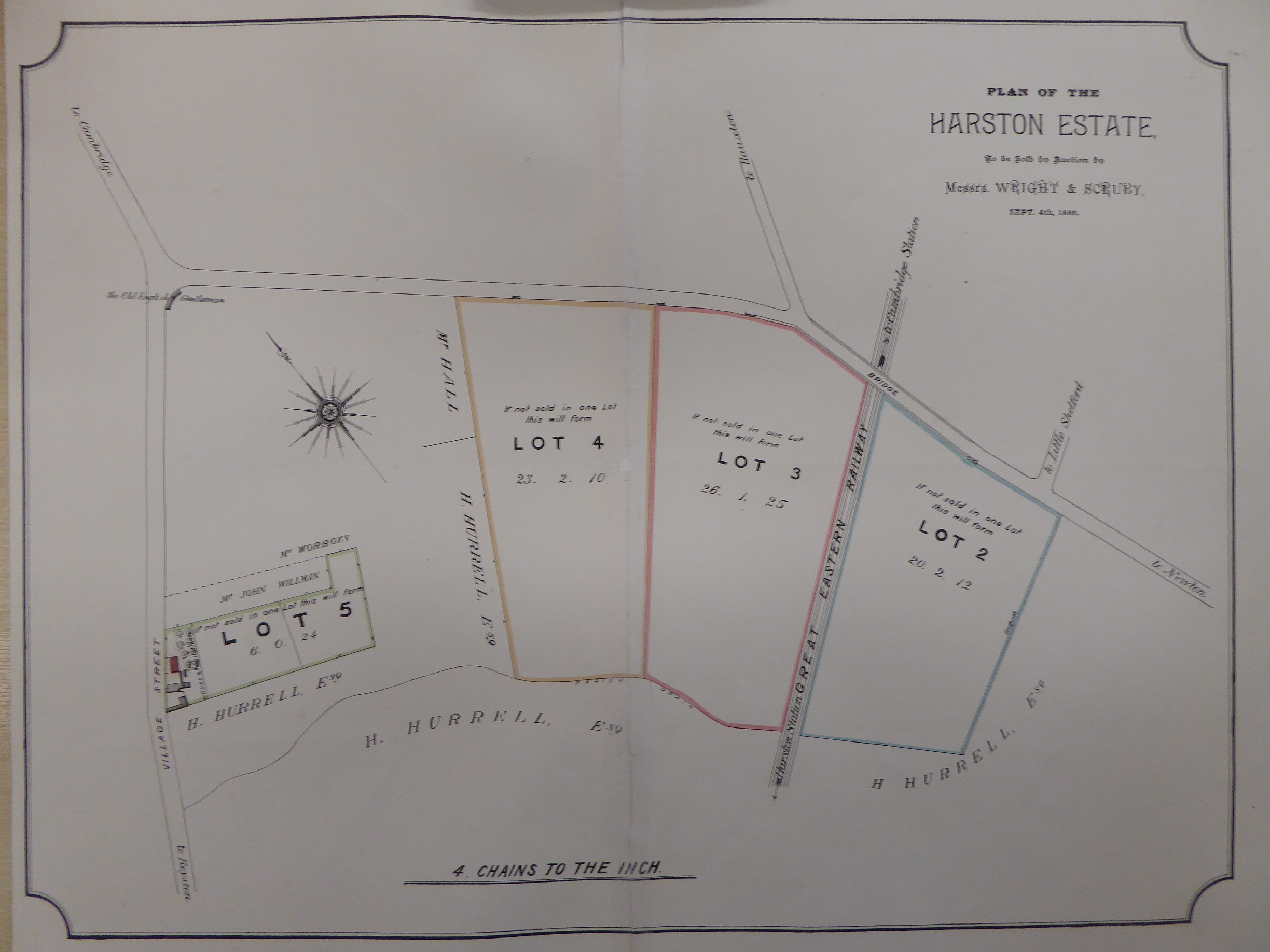
Originally a farmhouse called the Old Manor house was built on the site that later had No’s 104 & 106 high St houses built on it. Prior to the farmhouse being built the land was Common land for grazing before Inclosure in 1802 so the farmhouse was built between 1802 & 1881. In 1799 the Inclosure map shows that the land Manor House Farm buildings were built on and the adjoining small fields belonged to Thomas Whitby and T/E? James and the 3 large fields fronting London Rd (shown in 1886 lots 2-4) belonged to Henry Lyell.
An 1886 sale document states for this Manor Farm that:
Lot 5: ‘The Homestead’ is situated at the entrance of the village from Cambridge, and consists of a FARMHOUSE with a pleasant aspect, built partly of brick and partly of stud and plaster, and covered with slates. It contains 3 Lower and 6 Upper rooms, with 2 Kitchens, Dairy and the usual Domestic Offices. There are also 2 Barns, Nag and Cart-horse Stables, Chaff House, Cow lodge and Piggeries, Open Shed , Granary & Fowl Houses, and other buildings all in good repair. And adjoining the house is a Good Garden and Productive Orchard.
Lots 2, 3 & 4: The remainder of the Farm which is Arable consists of 70A, 2R & 4P of first rate corn and sheep land in a good state of cultivation, lying in 3 fields fronting the road leading from Cambridge to Newton.
By the time the farm was sold in 1886 the land around the Manor house and Manor house were shown as Lot 5. Lots 2-4 may have been sold separately in the end. See estate sale map.
Occupied by farmer Robert Pick
The whole farm in 1886 was in the occupation of Mr Robert Pick, as a yearly tenant at a rental of £112 per annum, and was sold subject to his rights of tenancy.
Several newspaper reports state he lived and farmed there from at least 1881-1894.
1881 October 8 Cambridge Independent Press
Eliza Corell summoned for wilfully damaging a hurdle belonging to Robert Pick. Fined 6d plus costs.
1889 June 8 Cambridge Daily News
Lightning caused a fire in a haystack, property of Robert Pick of Harston.
1894 December 7 Cambridge Independent Press
First Harston Parish Council Meeting, at the Board School, 60 people present Election of officers (Mr Thomas Gwilliam moved; Robert Pick seconded), the following were nominated (with no. of votes in parentheses), WT Rowley, farmer (53), R Pick, farmer (49); CJ Ives, gentleman (44); F. Willers, builder (44), J. Rodwell, farmer (34); P Hammond, labourer (28), SB Northrop, labourer (25), H Hall, carpenter (24), F Tuck, labourer (17), J Rouse, painter. The first 7 were duly elected.
Farmhouse residence separated from farmland
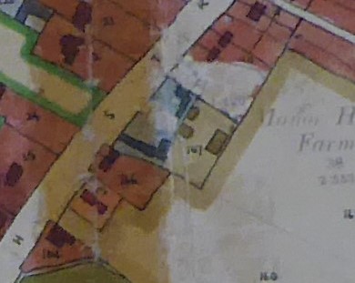
1901 O.S. map shows that the Manor Farm House is part of plot No 39; barns and farm buildings are still to the south of the house on the map.
1910 land use evaluation map and associated information show for plot No 238/39 there was still a House & garden of area 2R 31P and this was occupied by C P Gaul with the owner James Bacon Rampling of Landsdown Rd, Cambridge. However, all the farmland and most of farm buildings to the south of the house belonged to Hurrells of Park House opposite, so by this stage the house and farmland had been separated.
Mrs Bliss’s Old Manor House
From at least 1915- Jan 1940 the old Manor House was lived in by Mrs Gertrude Anne Bliss. WI records show she was active in village life and enjoyed producing charades for WI entertainment. Her address was given as the Old Manor House – seen to the left in the high St photo . Her daughter Dorothy Gertrude lived there presumably until she married in 1923. She had worked for the VAD as nurse in WW1 and illustrated a book on the VAD working in the convalescent hospitals for soldiers during the war. The book published in 1917 was called ‘In Blue and Grey’ by Lorna Cobbold with profits to the Red Cross.
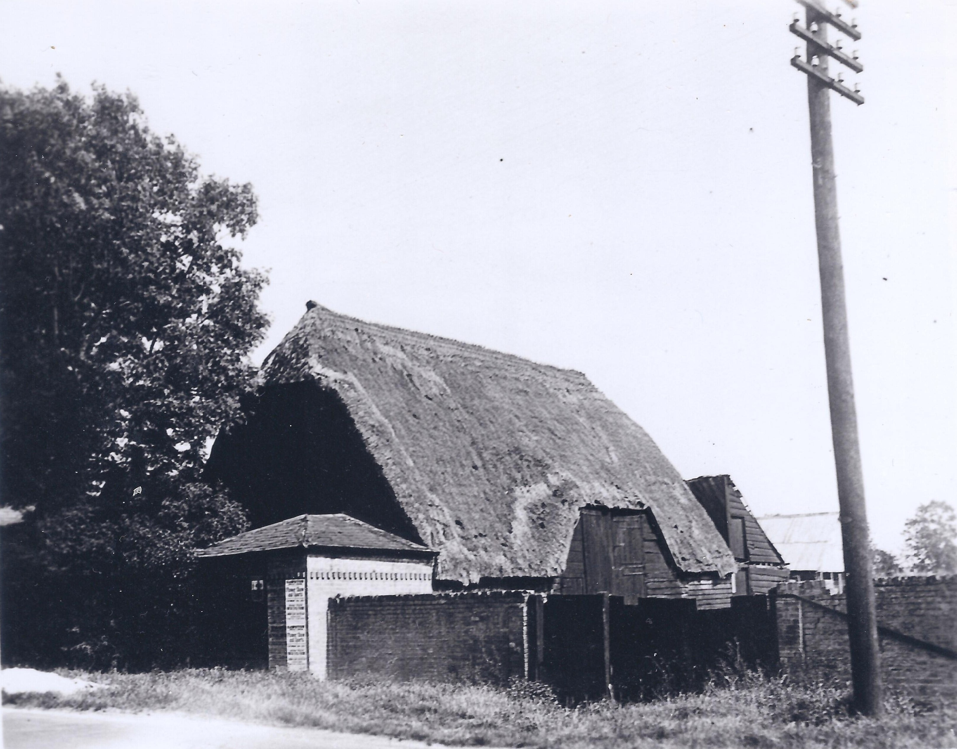
The house was used by soldiers in WW2 and accidentally burnt down but a number of farm buildings seem to have survived as shown on 1949 land use map and in the photos of the barn.
Farm buildings change of use
The 1949 land use evaluation map shows No 167 was farm yard & farm buildings in light brown that were still used attached to fields (160-62 to east (right). Fronting the High St was an auction yard – presumably Stockers car auction yard. Plot 168 has the Auction yard shown in blue. the newspaper report below details this.
1945 June 29 Bedfordshire Times & Independent:
GM Morris, auctioneer, is instructed by Mr PK Stocker et al., High Street, Harston, who are offering 50 motor cars for sale, including a 1934 Rolls Royce, Austin 7, 10, 18, Hillman 10, 20, Rover 14, Ford V8, Wolseley, Essex Terraplane, Ford 8, 10, Bedford lorries,, vans etc. Sale every Thursday.
A move to residential use
In 1946 plans were drawn up for Pest Control Ltd to build 3 pairs of semi-detached houses for their workers between the remaining farm buildings and Manor Close. The end house, now 108 high St was then lived in by Janet Bennett (nee Hill) in the 1940s who said: ‘Our house at one end of the row had a larger garden with a brick area on which we played which may have been the kitchen of the old house (once had an iron stove that was removed).’
The Plan for the Pest houses shows the remaining farm buildings, possibly including the large old barn.
Cheryl Marriott remembers ‘in the mid-1960s there was an empty plot (old auction yard) to the right of 108 where two Chapman families lived, first in caravans, then they built two houses before 1963 of the same design but mirror image. These were No 104 and No 106 High St shown on the 1971 OS map. One or two of the old farm buildings seem to have been included in the Nos 104 and 106 land but one old building seems to have remained attached to Manor House farmland.
One family had 5 children (Michael, Neil & twin Joyce, who married Colin Vallis, Terry and Fay). These Chapmans later moved to a Royston Rd cottage near Irene Deacon and then moved to bungalow in London Rd and died several years ago. Joyce who married Colin Vallis moved into Thompson’s carriage, but she died (of blood clot) straight after having a baby.
Motor repair businesses
As the photos show Nos 104-6 had car repair workshops behind the houses. Frank & Neil Chapman ran car body shop business.
In 1967 the authorities gave a refusal to rebuild existing motor repair shop at No 106 but in 1969 permission was given for C Chapman for a motor repair shop to the rear of No 106; the forecourt of which was still used for display of motor vehicles for sale.
1971 No 104 also applied to replace the workshop behind their dwelling. Mr F Chapman advertised that he bought, sold & gave part exchange for all makes of motor vehicles.
In 1979 Mr Roy Stickler had to shut down the showroom part of his motor cycle business, enforced by the local authority.
Building of a new road
In 1997-8 No 104 was demolished to permit the construction of High Meadow entrance road.
The car business still continued at No 106. The 2014 photo shows it as Gemtech.
Property development
Around 2016 No 106 was bought and the owner eventually bought No 108 too. by using the gap between the two the new owner was given permission to build another house which was designed to fit in with the existing ones and perhaps provide more affordable housing. The new house to the left of No 106 is shown in the Oct 2017 photo. access to workshop buildings at the rear of No 106 still remains.
Plans to convert these rear workshop buildings to a residence have not yet been given permission.
In 2020 No 106 is in the process of being extended a shown in the photo.
No Comments
Add a comment about this page